The recent Government announcement regarding the preferred corridor for a new road between Oxford and Milton Keynes has received a mixed response. Before we consider the implications of the proposal, it is important to understand its history.
What is it?
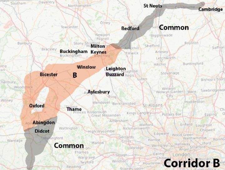
The new road forms part of the proposed Oxford to Cambridge Expressway – dubbed the brain-belt expressway – which will use a mix of existing and proposed main roads between the two cities (see map below). This includes the existing A421 dual carriageway between Milton Keynes and Bedford and the proposed new road between Oxford and Milton Keynes, which is likely to be a dual carriageway with grade separated junctions.
Who is proposing it?
The proposal comes from Highways England which is the Government agency responsible for motorways and trunk roads.
Why is it being proposed?
To improve road links between Oxford, Milton Keynes and Cambridge which is seen as an area with much potential for new development for housing and employment. The Housing Minister (Kit Malthouse MP) wrote to local authorities in this area on 26 July 2018 inviting proposals to help deliver one million homes in the period up to 2050 or in the next 32 years which equates to an additional 32,300 new homes per annum.
Where will it go?
The Government has chosen to follow Corridor B which broadly follows the existing railway line, although it remains unclear whether the road will go north or south of Oxford.
When will it happen?
The Expressway is scheduled to open in 2030, although the need to agree a detailed route, secure all the land required, obtain approval for the route, secure funding and build the road, notwithstanding the risks of judicial review by those opposed to the proposal, means that the road may open later than 2030.
How will it be delivered?
It will be delivered by Highways England as a government project working in partnership with the relevant local authorities such as Oxfordshire County Council, Buckinghamshire County Council, Cherwell District Council, Vale of White Horse District Council, South Oxfordshire District Council and Aylesbury Vale District Council.
What are the implications?
Those living in the preferred corridor face a period of uncertainty until the definitive route is decided.
It also means uncertainty for those who are seeking to identify land for future development such as local planning authorities and the development industry. The lack of any decision on the route of the corridor around Oxford – it could north or south – is very unhelpful for those making decisions about the location of future development. The current level of congestion on the A34 west of Oxford may mean the route is more likely to be to the south of the city.
The locations of junctions on the Expressway will be a key issue for the future allocation and promotion of strategic sites for development. Such junctions are likely to be with other strategic highways such as the two motorways (M40 and M1), two trunk roads (A34 and A5) and A class roads such as the A4074, the A40, A4146 and the A413.
The future location of new railway stations in locations such as Winslow could be an important factor in the location of major new housing allocations.
The preferred corridor provides a broad indication of the likely route, but there remains much uncertainty for all those who live and work within that corridor until a more detailed route is agreed. According to Highways England, the more detailed route is likely to be the subject of public consultation next year with a Government decision on the route in 2020, construction starting in 2025 and opening in 2030
The Expressway would improve journey times for many and it is also likely to act as a catalyst for new development.


.jpg)